Cime des Collettes - walk - hike
Cime des Collettes is listed in the Rando Pays Moyen, It is a circular walk based at Toudon. If you are driving east to west (from Gillette) the walk starts just after the wash house on the right and sign posted with the usual wooden signs.
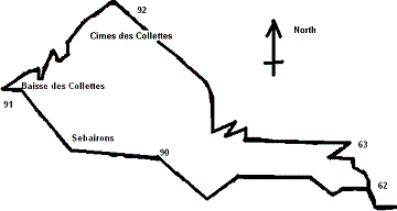
Set off up the path and you will cross a lane continue until you get to sign post number 62 and take the left fork to Baisse des Collettes and Sebairons. At Sebairons the area flattens out and there are a few deserted buildings, the path then goes up to the right to the Baisse des Collettes.


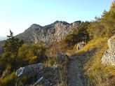
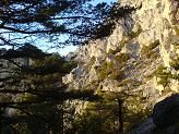
Baisse des Collettes is a cross roads just take the first right to Cimes des Collettes , which almost due east. The image below is looking back at the Baisse des Collettes. As we did the walk in late November and in the afternoon the light was falling fast and we were entering the darker side of the Mountain as we moved north and east the difference in light is evident from the next picture which faces north looking into the valley of the Var river.
On the western side we get an excellent view of Mont Vial as the sun was setting and the clouds had formed for the last picture of the day. From there it was a quick descent as we were running out of light and we were descending through cloud.

Walk Details 

IGN Map: 3642 ET
GPS Datum: UTM-WGS84
Waypoint Start 61 Easting 32:348374.42 Northing 32:4862660.47 Altitude 992
Waypoint 90 Easting 32:347191.84 Northing 32:4863017.39 Altitude 1195
Waypoint 91 Easting 32:346375.47 Northing 32:4863462.09 Altitude 1270
Waypoint 92 Easting 32:346985.49 Northing 32:4863881.35 Altitude 1437
Waypoint 63 Easting 32:348169.88 Northing 32:4863046.93 Altitude 1159
Distance 6 km height gained 585m difficulty medium
