Circuit de Viérou - Coursegoules - walk - hike
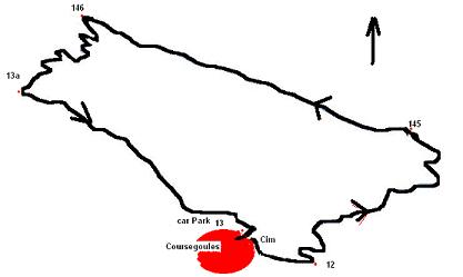
This is another favourite walk which we tend to fall back on quite regularly. It's a circular route going from Coursegoules village up to the escarpment along the top then back down going past the Chapel of St Michel and on to the village. To get to the start you need to drive up to the village from the D2 and Vence turning off on the D8 and approaching the village from the south. There are 3 turnings into the village. From that road take the 3rd turning for the village centre, almost doubling back on yourself. As you enter the village there is a bar on your left with tables on the other side of the road with a good view of the valley. There is parking along that stretch up to the town square and there are more parking spaces if you continue through the square and take a sharp right up a small rise to behind the square. The walk starts from this car park at the rear of the square. Facing the village turn left and follow a minor road to the village cemetery, follow the road around to the right and then to the left and the 1st signpost (No 12) should be visible on the left. We have done this walk at all times of year and in all weathers but in winter you need to be aware that the conditions can change very rapidly in the mountains, so you have to be prepared with extra clothing and water/wind proofs.
I would also grade this walk a medium as it is only 7km and the terrain is good. From sign post No 12 the walk climbs, zig zagging all the way

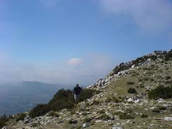
to a knoll - you go through a wooded area emerging on to a saddle before the final ascent. The final ascent zig zags again to sign post No 145 where you are on top of the escarpment with great views of the valley below and the hinterland behind. There is a microwave dish that services the village on the crest of the escarpment and just after that there are many flat areas with protection from the wind that prove ideal places for lunch.
The path is marked but goes over rocks so is not always so clear but eventually you start to descend to sign post 146 then take the zig zagging path down the mountain to sign post marker 13a. From there on, the path levels out and takes you past the Chapel of St Michel. Take the south eastern corner of the glade to keep on the path. The path then takes you down the side of the valley to a point on the opposite side to the village where it drops into some trees that hide a fording place for the stream. On the other side of the stream is a direct ascent into the village and the car park.
Flat distance 7091.73 m
Total height ascended 533 m
Actual distance 7223.51 m
Minimum height 1010 m
Maximum height 1421 m
Trail : Waypoints
CP East: 32:342372.58 North: 32:4850971.50 Height : 1024 m
13 East: 32:342802.36 North: 32:4850879.17 Height : 1080 m
12 East: 32:342746.43 North: 32:4850923.63 Height : 1084 m
145 East: 32:343304.83 North: 32:4851496.69 Height : 1354 m
146 East: 32:341655.50 North: 32:4852224.74 Height : 1406 m
13a East: 32:341362.98 North: 32:4851897.89 Height : 1176 m
CP East: 32:342372.58 North: 32:4850971.50 Height : 1024 m
